The Land of Jesus’ Ministry
About AD 30 · Maps for reading the Gospels and Acts
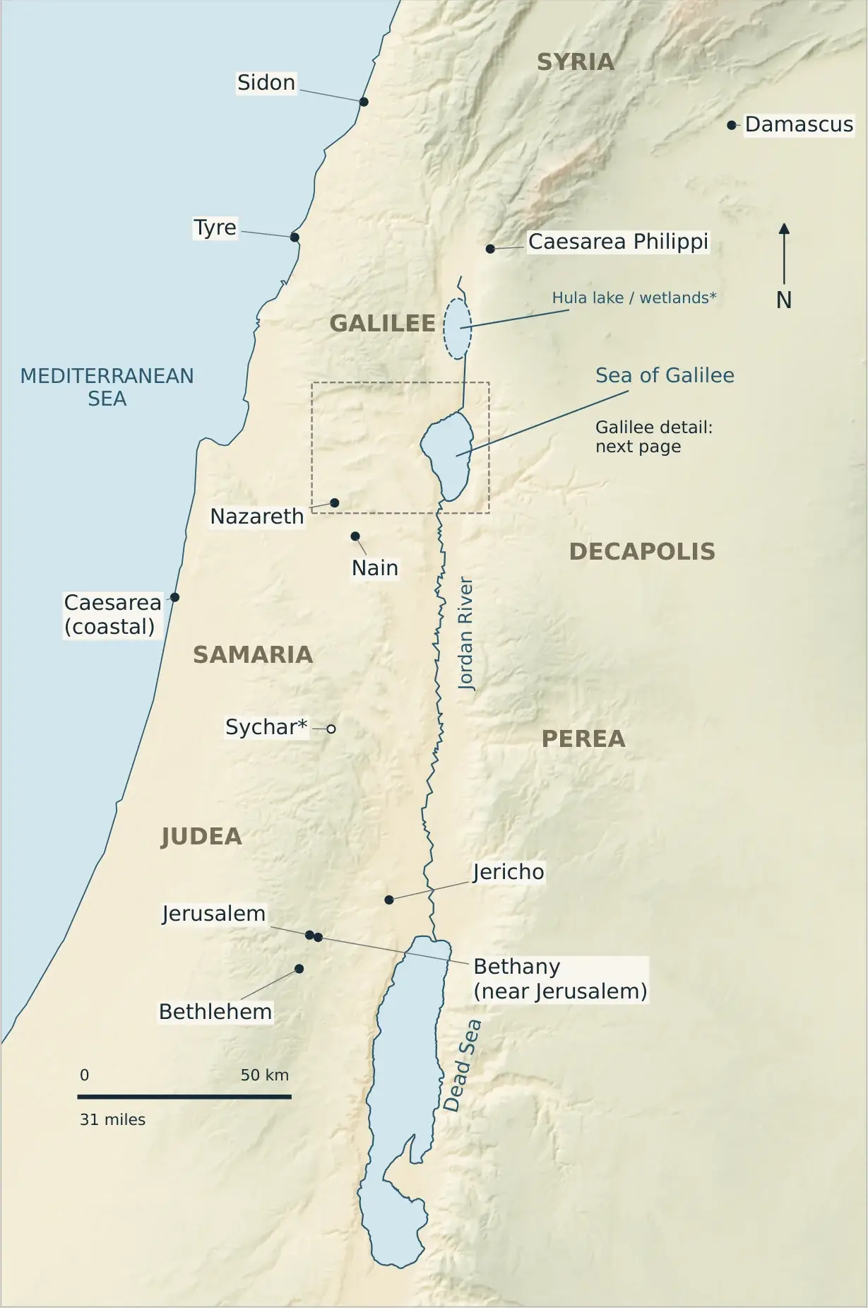
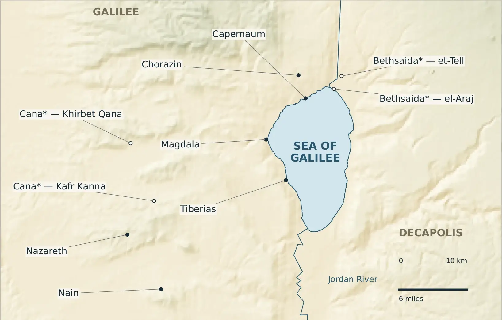
Use these maps alongside your Bible reading. In the reading window on this site, tap a place name such as Capernaum, Cana, or Jericho to see it circled on the map.
Overview and northern context
Galilee detail
Places and passages
Tap a reference to read the passage in the reading window.
| Place | Read | Map |
|---|---|---|
| Nazareth | Luke 4:16 | Galilee |
| Cana* | John 2:1–11 | Galilee |
| Capernaum | Matthew 4:13 | Galilee |
| Bethsaida* and Chorazin | Matthew 11:21 | Galilee |
| Tiberias | John 6:23 | Galilee |
| Nain | Luke 7:11 | Galilee |
| Sychar* | John 4:5 | Overview |
| Jericho · Jerusalem | Luke 19:1 · Luke 19:28–48 | Overview |
| Bethlehem | Matthew 2:1 | Overview |
| Bethany (near Jerusalem) | John 11:1, 18 | Overview |
| Caesarea Philippi | Matthew 16:13 | Overview |
| Decapolis | Mark 5:20; 7:31 | Overview |
| Tyre and Sidon | Mark 7:24, 31 | Overview |
| Damascus | Acts 9:1–19 | Overview |
| Caesarea (on the coast) | Acts 10:1 | Overview |
* Disputed identification: the town certainly existed, but its exact site is debated.
Places handled with care
- Cana and Bethsaida each show two competing candidate sites; neither is presented as certain.
- Sychar is marked at the proposed site of Askar.
- Jericho marks the New Testament (Herodian) town, not Tell es-Sultan, the older mound.
- Bethany is the village near Jerusalem, not the “Bethany across the Jordan” of John 1:28.
- Magdala is shown as background for Mary Magdalene. It is not assumed to be the “Magadan” of Matthew 15:39.
- Damascus and coastal Caesarea are included for Acts; including them does not mean Jesus visited them.
What the maps mean
The terrain version uses measured modern elevation data, exaggerated for readability, and earth tones for an atlas look. It does not claim to show first-century vegetation. The coastline is a modern baseline, and the Sea of Galilee and Dead Sea outlines are generalized. A dashed symbol north of the Sea of Galilee marks the Hula lake and wetlands, which were largely drained in the 1950s; its ancient shape needs further research. Modern roads, borders, and towns are left off.
Sources
Town positions: OpenBible.info Bible Geocoding (CC BY 4.0). Jordan River: © OpenStreetMap contributors (ODbL). Coastline: Natural Earth (public domain). Relief: Terrain Tiles from AWS Open Data (Mapzen/Tilezen; SRTM and GMTED2010 courtesy of the U.S. Geological Survey; ETOPO1 courtesy of NOAA), accessed November 8, 2026. Site identifications checked against BiblePlaces.com (Cana, Bethsaida); Hula: Bar-Ilan University (2021); Sea of Galilee levels: Scientific Reports (2022).